
Weather Alert: Winter Storm Stella
5 Things to Know About Winter Storm Stella
Winter Storm Stella is poised to be a high-impact snowstorm for the Northeast to start this week. Stella will also bring some snow to the Midwest, and has already dusted parts of the South.
Here are five things to know about the storm right now.
1) When Will the Heaviest Snow Hit the Northeast?
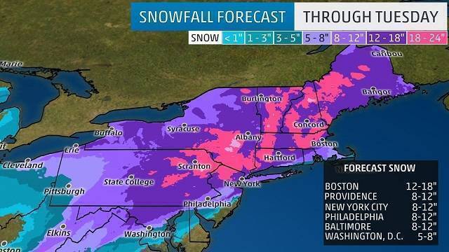
The heaviest snow will progress from south to north across the Northeast region late Monday night through Tuesday. Snowfall rates of 1 to 4 inches per hour are possible at times during the height of the storm near and west of the Interstate 95 corridor, including Boston, New York City. Those high snowfall rates could also occur near or northwest of both Philadelphia and Washington D.C. for a time.
2) Blizzard Conditions, Tree Damage and Power Outages Possible
Strong winds gusting from to 40 to 60 mph could cause near-blizzard or blizzard conditions to occur close to the coast from northern New Jersey to the New York City metro and parts of southern New England.
Inland areas away from the coast will also see low visibility and dangerous travel conditions during the storm.
The weight of the snow on branches and power lines in combination with the strong winds may lead to tree damage and scattered power outages in parts of the Northeast.
3) Stella Could Be New York City’s Fifth March Snowstorm of a Foot or More
A foot of snow from Stella is possible in a large swath from the mid-Atlantic to New England. Areas that see persistent, heavy bands of snow could see up to 18 inches or more of total accumulation. Stella could be New York City’s first March snowstorm of a foot or more since March 3-4, 1960. Just four of the 36 snowstorms that have dumped a foot of snow on the Big Apple since 1869 have occurred in March, the National Weather Service says. The latest in the season New York City has seen a foot of snow in a single storm was March 12-14, 1888, when 21 inches piled up.
4) Stella a Midwest and Southern Snowmaker, Too
Stella has also brought snow to the Midwest and parts of the South since this weekend.
Up to 10 inches was reported near Watertown, South Dakota, while parts of southern Minnesota and northern Iowa have seen more than a half foot of snow. Chicago had seen 2.2 inches of snow from Stella as of Monday morning, marking the first time an inch of snow has been on the ground there since Christmas Day.
5) Reconnaissance Flights Providing Extra Data
Air Force Reconnaissance Aircraft have provided additional data ahead of the storm for use in computer models that output weather forecast information. Extra data was provided by five dropsondes over the Gulf of Mexico during a flight there on Saturday. Another flight was scheduled for Monday to provide additional information about the atmospheric environment in the western Atlantic Ocean. Reconnaissance missions are occasionally performed in the winter when there is the potential for a major winter storm in the United States. This is similar to how these missions are used during hurricane season to collect data on tropical cyclones and the environment around them.
We recognize the severe impact that current conditions are having on our customers and we are committed to restoring service levels as quickly as possible. As a result these weather issues, the ALG Client Service Team will send daily updates as we monitor the storm’s progress and track job level impact.
Leave A Comment
You must be logged in to post a comment.